School Boundaries
Elementary Schools
For an interactive school boundaries map by address, please click here.
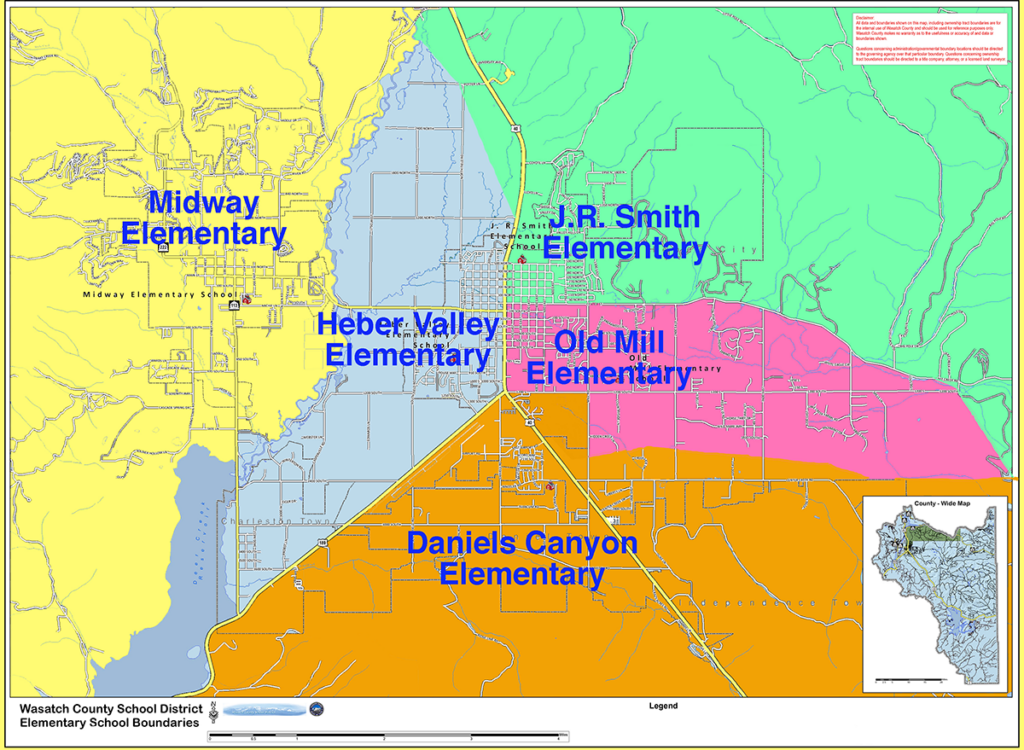
J.R. Smith Elementary’s boundaries include all of the homes on the north side of Center Street and East Lake Creek Road which are on the East side of Main Street. The boundary goes north on Highway 40, including the homes on the east of Highway 40 until it reaches 1200 north. At 1200 north, J.R. Smith includes both sides of Highway 40, including the homes east of North Field Road on Porter Lane continuing on to the Provo River. Students living in Hideout (Todd Hollow) on the north end of the Jordanelle Reservoir will attend J.R. Smith. Also included in the J.R. Smith boundaries are the areas east of Heber: Greener Hills, Little Pole, Big Pole, Red Ledges and Timberlakes.
Old Mill Elementary includes the students on the south side of Center Street as it goes East until it joins with East Lake Creek Road which then continues on to meet 1200 South. All homes on the east side of Main street from Center Street to 1200 South are included in the Old Mill boundary. Homes on the east of South Highway 40 will attend Old Mill if they are north of 1200 South. From that point, the boundary goes south and east, running roughly parallel to Center Creek Road, but not including those homes on streets only accessible from Center Creek Road.
Daniels Canyon Elementary includes the homes on the west side of Highway 40, beginning at 1200 south, crossing highway 40 and including both sides of the highway to Mill Road at its easternmost boundary. The north eastern boundary of the school includes all homes adjacent to and on Center Creek Road as well as all homes south of Center Creek Road. To better provide for student safety, a bus will be provided to transport the students who attend this elementary school and whose homes are east of Highway 40, regardless of physical distance from the school. The western boundary of the elementary school runs down highway 189, taking all the homes on the east side of the highway.
All of the students who live west of Wighway 189 and west of Main Street in Heber, but east of the Provo River, attend Heber Valley Elementary. The western boundary of Heber Valley Elementary follows the Provo river to the Jordanelle Dam. Wallsburg, Hidden Meadows, Charleston, Casperville, and students who live in the north fields area attend Heber Valley Elementary. The North Fields area does not include those students who live in the proximity of Highway 40. Those students in northwest Heber are in the Heber Valley Elementary boundary. To insure the safety of these children crossing Midway Lane, controlled crossing was created by the Heber City Police on Midway Lane. In addition, a bus is provided for the students in northwest Heber who live west of Main Street and north of Midway Lane.
Midway Elementary serves all of the students west of the Provo River. The boundary follows the river north to the Jordanelle dam. Midway’s boundary continues along the western shore of Deer Creek Reservoir to Deer Creek Dam.
Middle Schools
The 6th, 7th, and 8th grade students living within the elementary boundaries of Heber Valley Elementary and Midway Elementary attend Rocky Mountain Middle School. Those 6th, 7th and 8th grade students living within the elementary boundaries of Old Mill Elementary and Daniels Canyon Elementary attend Timpanogos Middle School.
Elementary School Boundaries Map